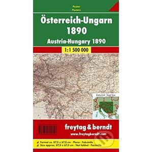
The Austro-Hungarian Empire in 1890 on a reproduction of a map produced by Gustav Freytag for his cartographic company in Vienna. The map, drawn at 1:1,500,000, shows internal administrative provinces within the Dual Monarchy, from Bohemia, Moravia, Silesia and Galicia in the north to Bosnia and Herzegovina in the south, with coverage including the neighbouring areas of the Balkans. The map shows railway lines. Skillfully executed hachures present the relief, with plenty of names of geographical features. Latitude and longitude lines are drawn at 1° intervals. Nástenná mapa: Rakúsko, Maďarsko od authora a nakladatelství za skvělé ceny na e-shopu Martinus. cz.
| Jazyk |
anglický |
| Rok vydání |
2017 |
| Žánr |
cestopisy |